



NOW WE ALL KNOW WHAT THE GPS AND ARE AVAILABLE AT LITTLE MAPS AND SOPHISTICATED NAVIGATION SYSTEMS, BUT HAD A BEGINNING, THIS IS MY SMALL CONTRIBUTION TO THEIR STORY ...
GPS (THE BEGINNING)
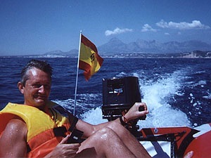
GPS Garmin 45
Thanks to a small portable device (in this case a Garmin 45) any person without prior knowledge of cartography and with the help of a single plane scanning and calibration can establish their position with great precision, if also connected our laptop to a GPS (Power Book 1400), with the help of specific software (Pro MacGPS 2.2.2) can greatly enhance your chances since our computer work as a plotter for us showing our location on a pre-calibrated level, further indicating our position, speed course so accurate. The Garmin GPS-45 is basically a receiver that receives signals from a geostationary satellite system in space by NASA, this complex system is permanently controlled by a ground tracking system. Due to differences in the time of reception of each satellite in the GPS, and with the help of built-in microprocessor calculates its position on the surface of the earth with great precision.Se powered by 4 batteries common, although it may take feeding
any external device through a connector with a very wide voltage range which facilitates their operation. Having a mount can be attached the GPS to a surface, if it can not be maintained and operated with one hand.
Manual use of the GPS
Connection to the Macintosh
We make a cable that allows us to connect the GPS to MAC, which is necessary to order the kit and make the connection interface to a mini din 8 to anger the communications port of our Powerbook. The information collected by GPS can be stored on the hard disk and can be digitally up all points of our itinerary, for example a road or trail collected. In addition to the stored waypoints or waypoints we can address any of them by pressing a button, the GPS draws a corridor to that point as to whether the chosen path is correct if and where there is deviation, the approach speed, estimated time of arrival etc.
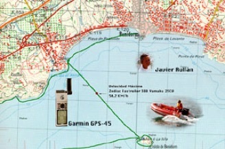
To reflect our position in a plane, we first scan the map on the computer, then be calibrated on the basis of the map projection that was used to generate the plane which are many. In our case we use the popular high-precision military planes and are of a UTM and are very easy to obtain and calibrate, for it simply by selecting three points in the plane and tell the program what their coordinates. In the picture above we can see the military side of the bay UTM Benidorm (Alicante Spain ECC) and the green solid line the route taken by the boat, he surrounded the island of Benidorm to verify the correct calibration of the plane and check the operation GPS.
The itinerary shown is performed aboard a Zodiac Futura FastRoller model equipped with a 25 HP Yamaha engine
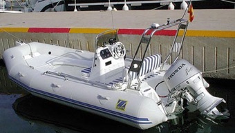
thanks to the GPS points could be measured speeds exceeding 50 km / h.
In all those outdoor activities (hiking, climbing, hiking, raid, nautica, cross country motorcycling etc.) can be very useful at all times to give us our exact position, both day and night as opposed to traditional positioning systems that required the vision of the sun or stars to put our position, so if the weather conditions were bad is it impossible. To receive the GPS signals is important to the absence of solid objects that interfere with the signal with at least 3 satellites, the glass does not interfere with the signal, which can be used inside a car, if it became necessary, can be connected to an external antenna. The nautical theme is important to note that given the importance of the determination of our position is mandatory manteniento traditional systems to avoid the possibility positioning due to mechanical failure or breakdown in the GPS satellite system run out of coverage position, in this sense levels of security over any other consideration. In the case of navigation to make shore that is watching our case this point is not necessary.
In the picture right is a fixed installation in a rigid inflatable, Zodiac Medline, the GPS is mounted on a support and is powered directly from the boat battery, so you get unlimited autonomy.
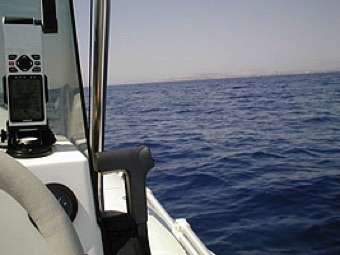
GPS fixed Installation
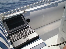
The system itself can power a laptop, in this case an Apple PowerBook 145, low cost, to make the plotting of planes with great precision and collect all the track log on the hard disk, the computer acts somewhat like a digital recorder GPS data.
We need this installed GPS Software Mac Pro on the computer, which when connected to the GPS real-time returns us lots of information, stored in turn in the hard disk. To purchase this program should contact the authors: James Associates. P.O. Box 601 Nederland, CO 80466. USA. In the photo above is a fixed installation in a rigid inflatable, Zodiac Medline, the GPS is mounted on a support and is powered directly from the boat battery, so you get unlimited autonomy. The system itself can power a laptop, in this

If in addition we have a calibrated flat area where we are, this software not only shows the parameters of position coordinates in the computer speed, etc., but it is important and this draws our position in the plane, ie it acts as a plotter, which greatly facilitates navigation at any time by telling us that we are the exact site. The low power of the computer used in this case in terms of disk capacity and RAM, does not permit the use of complex plans so we will use calibrated vector drawings in which only shows the contours of the coast and where to place waypoints superimposed known to easily check our position.
It is necessary for obtaining energy, placing a cigarette lighter type outlet in the console of the boat. In this case the installation is complemented by a low-cost sound check at any time the available depth.
In this case a cable is constructed that meets several requirements:
12 v Food GPS
Food PowerBook 7.5 v
Interconnection GPS data to the serial port of the PowerBook
This type of old laptop is perfect for the harsh treatment they may receive during its use, and are available on the used market at low prices. The information can then move on to other more powerful computers via floppy disks or a local network.
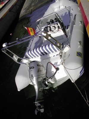
Today there are several GPS solutions for ships, including many mobile phones include GPS navigation system, yet it is well to remember that safety should always have the appropriate nautical charts with some alternative system of location especially if you navigate without sight of coastline.
With the AIS system transmits GPS position and an Internet access can find out the position of any ship in the world if it transmits its position, as you can see in this video
case an Apple PowerBook 145, low cost, to make the plotting of planes with great precision and collect all the track log on the hard disk, the computer acts somewhat like a digital recorder GPS data.
We need this installed GPS Software Mac Pro on the computer, which when connected to the GPS real-time returns us lots of information, stored in turn in the hard disk. To purchase this program should contact the authors: James Associates. P.O. Box 601 Nederland, CO 80466. USA.
Nowadays it is easy and cheap to add a GPS with sonar function to any boat, as is the case with this Garmin Echomap 42 DV that supports digital cartography.